A close adventure to Malone
Decisions, decisions, decisions! Where to go this week and what new area would I like to visit? It came down to crunch time, and then my buddy Mike gave me a shout about hiking on Wednesday. That helped me narrow it down a bit. Scanning my maps of the Franklin County region my eyes focused on two peaks that have the most unusual names: Humbug and Little Humbug mountains. That was it, and in perfect time for the Christmas holiday season. Through additional research I realized that Elephant Head was right near the two peaks and from what I could tell from all the reports on the web the trail was right to the north of the Humbugs. This access road and trail would be the perfect launching point into these mountains, and I got to visit a trail I'd never ventured to before.
With a modest meet time at the intersection of Route 30 and 86 in Paul Smiths, we quickly got our travels north to Malone underway. According to the web the access road had a trail sign and was located about 10 miles south of Malone right along Route 30. Lo and behold, there it was. Warnings were popping up about the access road not being in the friendliest condition to low clearance vehicles, so I half expected to hike the 1.5 miles of the road back to the actual trailhead. Well, we made it about a half mile up before I decided I didn't want to take a chance getting stuck in black waters along the road. We found a spot to nudge the van off of the road enough to let other cars pass if they were feeling lucky.

Trail to Elephant Head
The walk along the road was as if Mother Nature had spread out a walkway of rose petals, but rather than that the colorful leaves of an Adirondack autumn were under us. The road about two weeks prior must have been a wonderful spot in itself; I only wish I had been there to see it. A couple of hunters along the road were the only people we happened upon all day, and they looked to be calling it quits. We set our course and speed on cruise control until we finished off the 1 mile road walk. Arriving at the trailhead, we brought it down a gear and enjoyed the soft footing of the trail beneath us. As if welcoming us to the neighborhood, the chickadees gave us song.

The trail was estimated to be roughly a half mile to the summit and I was sure it wasn't going to be all that demanding, but with such heavy leaf cover the footing was a tad slippery and awkward as it covered the slightly rocky terrain before us. We made short work of the trail and were soon at the staircase to the summit. Slippery, old, and falling apart -- the staircase, not me -- it allowed us to get past the slippery section much more easily. We first visited the true summit, which gave us a slight view through the new growth to the Humbug mountains. Atop the summit rock sat a summit registry, so of course we signed it with the piece of charcoal supplied by the old school purveyor.

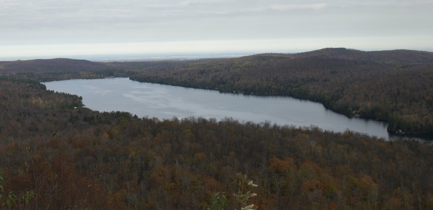
The secondary view was a much better reward. It encompassed Titusville Mountain, Tamarack Swamp and Lake Titus. Too bad the colors were so dim at this point; it must have been breathtaking a bit earlier in the season. The yellows of the tamaracks in the swamp set the shore on fire and gave us a dash of color in the bland landscape.

Off to the Humbugs
According to my trusty GPS we were only about 0.45 miles from the summit of Little Humbug Mountain, and the trail would get us a third of that out of the way. We left the trail iand entered open forest. The hardwoods were quite amazing in this area and under the leafless October canopy the sun wanted to warm our shoulders.
The terrain was steep but we were relentless, and with a well-placed switchback effort we topped out on the semi-open summit. It had steep sides so we looked around for views, and through the trees we reached out for a hazy observation of the mountainous terrain. The summit gave us nothing much more than the hope of finding something more. Little Humbug is made up of a long ridge and two high points of the same general height. The first one sits just outside of the Adirondack Park, but the other, about a quarter mile away, is within the Park's boundary. We crossed into the Park by foot, something I don't believe I have ever done before. The second high point, you ask? It didn't have much to offer either.

The descent was not steep, but it had its moments of slippery, loose leaf action. Once in the valley we were welcomed by terrain that gladdened any heart. The openness of the forest was the scenic high point up to now and the perfect place to have an early lunch.


Again the climb was steep, but that was mainly because we went right for the summit and didn't dilly-dally around trying to take pressure off of our quads. The summit came pretty fast even though we needed to traverse a couple of smaller knobs along the way. The summit itself was pretty neat, and not like many others I have encountered in the past. It was lined and covered in gnarly looking mountain ash and birch. It was super open all around us and the views were decent even through the twisted forest. The green of the ferns were still breaking through the orange leaves that lay about us on the forest floor, almost as though they didn't want to give up quite yet.
Call it an early day and back to the car we go
We made plans to head right for the access road below, and in a straight line it was 0.75 miles through open forest, down steep slopes, and through a shallow pass between two small rises of land. As a raven gurgled above us, casting its shadow on the land, we made a direct line over the rubble-infested slopes of Humbug Mountain. The thick coating of leaves again gave a challenge by covering the holes amongst the rubble, making walking a bit hazardous. Luckily it didn't last too long. Now in the shallow col of the two mountains we moved quickly along the drainage and eventually over it. The road came quickly after that. Covered in decaying leaves it was unnoticeable until we were right on top of it. Our ramblings in the woods had come to an end as we walked the road back to the car, looking back on the hike as pure enjoyment spent in the Franklin County forests.
Now we only had two questions: Where to next, and was the hot dog vendor at the parking lot? We answered both: Black and East peaks, and yes, he was. Once you're done dining, why not go on a shopping spree in Malone?


Comments
Add new comment